| |
| |||||||
 |
| | LinkBack | Thread Tools | Display Modes |
 09-06-2010, 05:22 PM
| #41 |
| RCC Addict Join Date: May 2010 Location: Los Altos, California
Posts: 1,509
|
name: Fremont Trail Opens where: Near Questa and Grant Intersection. How to find: from 237, go straight down Grant and stay in the Left lane. Once you pass by the Cuesta and Grant Intersection (about 3 stop lights from the 237 exit) there is a street called "Sleeper Avenue" Which is the 1st street on the left, after the cuesta and grant intersection class: Both history:Not sure, but not many people pass by. rating: 9stars, Some times there is dog Crap on the ground on the rocks :( google map location: http://maps.google.com/maps/ms?hl=en...f85068f6fed04f No Video but here are some pics.     Last edited by MRCCRAWLER1.9; 09-07-2010 at 12:16 AM. |

|  |
| Sponsored Links | |
| | |
|
09-06-2010, 11:48 PM
| #42 |
| Newbie Join Date: May 2010 Location: Santa clara
Posts: 35
|
Thanks for the spots, you never know who lives around there for a quick crawl. Also thanks for following the rules, the posts look great!
|
|
| |
|
09-06-2010, 11:53 PM
| #43 |
| RCC Addict Join Date: May 2010 Location: Los Altos, California
Posts: 1,509
|
haha glad to help the forum, i mean it looks like such a nice place to crawl. |
|
| |
|
09-07-2010, 12:03 AM
| #44 |
| Rock Stacker Join Date: Apr 2010 Location: sunnyvale
Posts: 64
|
what the pics show is what you get! both are spots ive hit up!! i got a bay area trail guide at a book store! then systamaticly trying to hit all the 100s of bay area trails, mostly all flat ground but one obsticle isnt really worht a second visit! Last edited by gardenwelder; 09-07-2010 at 12:07 AM. |
|
| |
|
09-07-2010, 12:05 AM
| #45 | |
| RCC Addict Join Date: May 2010 Location: Los Altos, California
Posts: 1,509
| Quote:
For the Fremont Trail open: thats about it.. there are some other rocks, but they arent compiled as much as the pics i got. | |
|
| |
|
10-19-2010, 01:00 AM
| #46 |
| Newbie Join Date: May 2010 Location: Santa clara
Posts: 35
|
NAME: Little Yosemite WHERE: Sonol Regional Wilderness, Milpitas, Ca. near Calaveras Res. HOW TO FIND: Don't drive up Calaveras rd at Milpitas(takes longer unless you want a good view of Calaveras res.) From 680, exit Calaveras Rd and head south into the Sonol Valley. Make a left on Geary Rd and you will head on down to a pay booth (yeah this one will cost you 5 bucks) ask for a map, very helpful! then keep right on the main road till you reach the parking lot at the end. Theres no un-authorized vehicle access after that parking lot on Geary Rd so you are going to hike for about a mile more. Just take the small side trail on the right about half way down. it runs along the creek where you will eventually see more and more rock. I only went as far as the brush lets you go, correct me if theres more, theres a few lines on the other side of the creek as well. CLASS: Mild comp, tons of scale trail HISTORY: Suggest to stay in your car at that parking lot until the rangers leave or stick your rig in a back pack. The sign at the trail-head says no model rockets or airplanes, but nothing about rc cars. GOOGLE MAP: http://maps.google.com/maps/ms?hl=en...f6442243b55991 VIDEOS: http://www.youtube.com/watch?v=ELvL-e1gSnQ http://www.youtube.com/watch?v=oiMFOcBQOrY http://www.youtube.com/watch?v=ZfZtcrh4Y5I http://www.youtube.com/watch?v=dYTW9p5Nlr0 PICS:  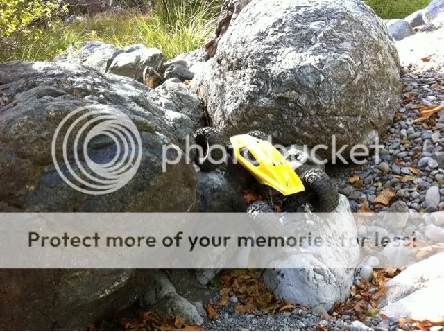 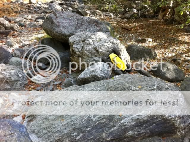    |
|
| |
|
10-20-2010, 12:04 AM
| #47 |
| RCC Addict Join Date: May 2010 Location: Los Altos, California
Posts: 1,509
|
aHHHHH XR-10 looks awesome!  nice find, howd you even find it? just randomly? lol Last edited by MRCCRAWLER1.9; 12-14-2010 at 11:23 PM. |
|
| |
|
10-20-2010, 01:13 PM
| #48 |
| Newbie Join Date: May 2010 Location: Santa clara
Posts: 35
|
Quick tip: trim down your quotes(backspace) or try not to quote and just do a regular post, this thread has long posts and takes forever to load. Each page I think has 20 posts no matter how big or small. If you search around, you'll find the nor cal google maps link, they are all well known locations. I'm just making it simpler to find and see what's there. |
|
| |
|
10-21-2010, 11:17 AM
| #49 | |
| Quarry Creeper Join Date: Feb 2009 Location: Orangevale
Posts: 223
| Quote:
Its listed here along with many others.... | |
|
| |
|
03-02-2011, 12:38 AM
| #50 |
| Newbie Join Date: May 2010 Location: Santa clara
Posts: 35
|
hi all, it's been a while. I recently moved so I havent had much time to do much scouting lately. I finally have a back yard so I will soon make a little addition to this thread If anyone knows of a non-coast spot in the south bay that is not listed in this thread, fill free to add it here. Also, if any conditions change in theses locations, let us know. I'll also work on updating them as well. Having a thread like this really helps out the noobs. |
|
| |
|
03-02-2011, 12:47 AM
| #51 |
| RCC Addict Join Date: May 2010 Location: Los Altos, California
Posts: 1,509
|
Glad to hear from you again dan, hopefully you didn't move too far away from the south bay. You might be able to find some rocks near creeks. I got a few rocks from the beach. Greystone, someone cut down alot of brush according to brownie, so there is a whole new section open in the back. Maybe like an extra 2min hike from the first boulder you see there. Linda, always muddy like the norm. Sheldons upgraded their course twice. The volcano island and a new one on the drift track. That's all I know off the top of my head. Last edited by MRCCRAWLER1.9; 03-02-2011 at 12:51 AM. |
|
| |
|
03-05-2011, 11:55 PM
| #52 |
| Pebble Pounder Join Date: Dec 2009 Location: scotts valley
Posts: 165
|
Hey crawlitreal here is a few more spots to check out. I know its not in the format you want. But, oh well. Enjoy! Arrows at Bayview is nice for me cause I can stop by on my commute home. Right off Hwy 17, then a 2 minute walk.http://maps.google.com/maps/ms?hl=en...2b260dc8f4329c |
|
| |
|
03-06-2011, 12:13 AM
| #53 |
| Pebble Pounder Join Date: Jan 2011 Location: Escalon Ca
Posts: 149
|
great thread dan! definitely need to check out Almaden rock
|
|
| |
|
03-06-2011, 01:42 PM
| #54 | |
| Newbie Join Date: May 2010 Location: Santa clara
Posts: 35
| Quote:
| |
|
| |
|
03-06-2011, 01:48 PM
| #55 | |
| Newbie Join Date: May 2010 Location: Santa clara
Posts: 35
| Quote:
| |
|
| |
|
03-06-2011, 09:39 PM
| #56 |
| I wanna be Dave Join Date: Jun 2004 Location: San Jose
Posts: 5,207
|
Man I thought you were trapped under somthing heavy. I'll be heading out to Almaden this week to test out Mugsy my race buggy. If anyone is down LMK
|
|
| |
|
03-06-2011, 09:43 PM
| #57 | |
| RCC Addict Join Date: May 2010 Location: Los Altos, California
Posts: 1,509
| Quote:
i dont have a legit buggy, i have a slash 4x4 converted buggy  | |
|
| |
|
03-07-2011, 07:03 AM
| #58 | |
| Pebble Pounder Join Date: Dec 2009 Location: scotts valley
Posts: 165
| Quote:
| |
|
| |
|
03-07-2011, 11:53 AM
| #59 | |
| Newbie Join Date: May 2010 Location: Santa clara
Posts: 35
| Quote:
| |
|
| |
|
03-07-2011, 09:23 PM
| #60 |
| Pebble Pounder Join Date: Dec 2009 Location: scotts valley
Posts: 165
|
Yeah Moon Rocks looks like alot of fun for scalers. I may try to go there this weekend. If so I will get pictures.
|
|
| |
|
| Thread Tools | |
| Display Modes | |
| |


 Linear Mode


