| |
| |||||||
 |
| | LinkBack | Thread Tools | Display Modes |
 03-11-2012, 05:21 PM
| #41 |
| Quarry Creeper Join Date: Nov 2011 Location: dark corner
Posts: 485
| 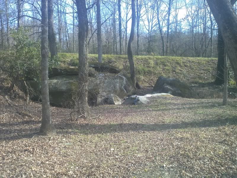 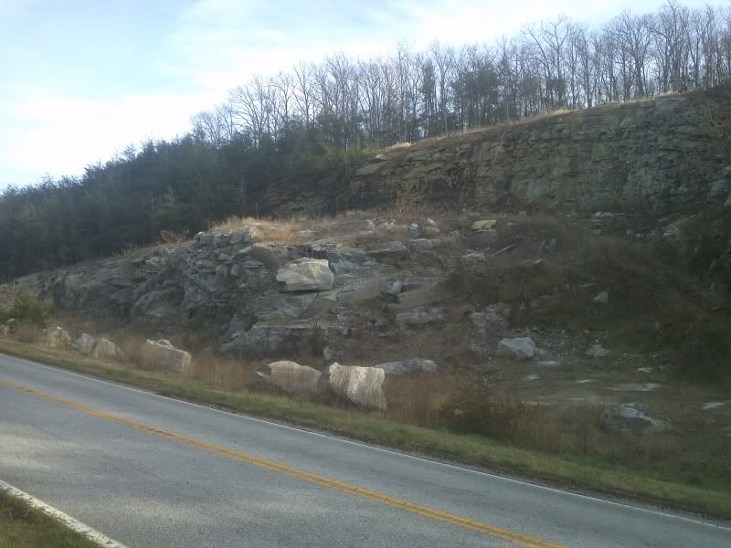 a couple more spots i discovered today that i can go practice with my comp rig there within 2 miles of my house if anyone wants to go to any of these just lmk |

|  |
| Sponsored Links | |
| | |
|
03-20-2012, 11:12 AM
| #42 |
| I wanna be Dave Join Date: Oct 2008 Location: Sumter
Posts: 6,141
|
Coordinates to the second pic?
|
|
| |
|
03-21-2012, 07:51 AM
| #43 |
| Quarry Creeper Join Date: Nov 2011 Location: dark corner
Posts: 485
|
I'll get them for you when I get back home but it's right outside of gowensville on hwy11
|
|
| |
|
03-21-2012, 07:56 AM
| #44 |
| RCC Addict Join Date: Dec 2007 Location: Ward, SC
Posts: 1,108
|
That second pic looks promising. How's the parking there?  |
|
| |
|
03-21-2012, 07:59 AM
| #45 |
| Quarry Creeper Join Date: Nov 2011 Location: dark corner
Posts: 485
|
You could park on the side of the highway and have room to walk around your car
|
|
| |
|
03-23-2012, 11:01 PM
| #46 |
| Quarry Creeper Join Date: Nov 2011 Location: dark corner
Posts: 485
|
35° 7'35.11"N 82°17'30.79"W thats the center of the second picture but the google earth picture still shows it with tree coverage that isnt there anymore! |
|
| |
|
03-24-2012, 12:47 AM
| #47 |
| I wanna be Dave Join Date: Oct 2008 Location: Sumter
Posts: 6,141
|
Google Street View shows it just fine... 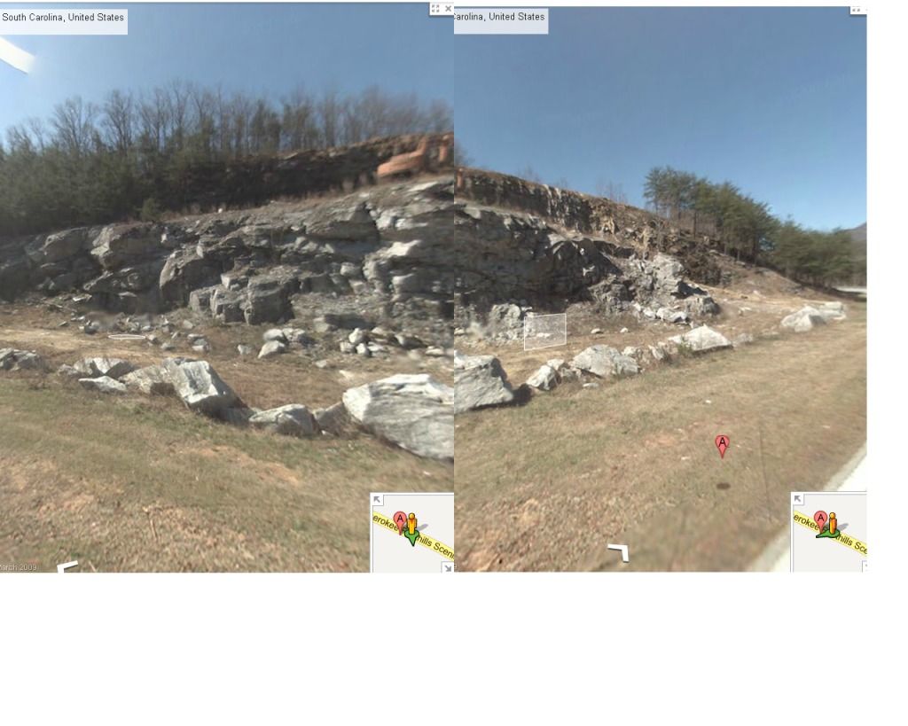 |
|
| |
|
06-04-2012, 09:31 PM
| #48 |
| Rock Stacker Join Date: May 2012 Location: sparkle city
Posts: 51
|
i mountainbike alot and think maybe yall should check out southside park in spartanburg,down hwy. 56 towardscross anchor. might be a great spot. hills,rocks,creek crossings around 14 miles of trail.Theres also croft state park next to it. |
|
| |
|
07-26-2012, 07:21 AM
| #49 |
| Rock Stacker  Join Date: Nov 2011 Location: Summerville SC
Posts: 60
| Google Maps I need to get the exact coordinates, but here is satalite view. No rock, but dirt, clay, and sand. Most is all washouts, so it changes every rain. It is near the corner of 17A and 176, Locally known as Carns crossroads. Plenty of parking, local PD has no issues if we clean up and not cause trouble/damage.  |
|
| |
|
07-26-2012, 07:27 AM
| #50 |
| Rock Stacker Join Date: Nov 2011 Location: Summerville SC
Posts: 60
|
Oh, and its in Summerville area. Yes, there a few of us down this way, and growing! we dont have much for rocks and such, but we still find great spots!
|
|
| |
|
08-01-2012, 07:11 AM
| #51 |
| Quarry Creeper Join Date: Mar 2009 Location: Yokota
Posts: 260
|
I think that riverbanks is getting harder about their policy about no water access. There is a fence going up at the end of riverbanks zoo parking lot. They never had a problem with us before. Think that it is because of the college kids going down to the water and causing trouble. Wonder if someone talked with them if we could come to some sort of agreement. It would really stink to lose one of the good spots in the lower central SC area. Sent from my Super Smart Smart phone using Midi-chlorians |
|
| |
|
08-01-2012, 07:45 AM
| #52 |
| I wanna be Dave Join Date: Oct 2008 Location: Sumter
Posts: 6,141
|
The zoo has always had a problem with people parking there...no matter what they're doing simply because if one group parks there 20 more will follow and someone will end up staggering through the parking lot harassing zoo guests.
|
|
| |
|
08-07-2012, 08:53 AM
| #53 | |
| Quarry Creeper Join Date: Feb 2011 Location: Wellford, SC
Posts: 495
| Quote:
 | |
|
| |
|
11-09-2012, 02:44 PM
| #54 |
| Newbie Join Date: Oct 2012 Location: Chas. SC
Posts: 30
|
has anyone scouted Earlewood Park in columbia?
|
|
| |
|
04-19-2013, 09:43 PM
| #55 |
| Quarry Creeper Join Date: Apr 2013 Location: Upstate
Posts: 335
|
Glendale Shoals in Spartanburg located in between Country Club Rd & Emma Cudd Rd. Public land open to anyone, easy to get there and plenty of parking, Consist of small deer/hiking trails and tons of rock along the river! Hopefully will be able to get some pics up soon. Location : 34.941781,-81.838814 |
|
| |
|
04-22-2013, 09:37 PM
| #56 |
| Rock Stacker Join Date: May 2012 Location: sparkle city
Posts: 51
|
i live bout 5 mins from glendale shoals went alot last summer been alittle while but really fun place to scale |
|
| |
|
05-24-2013, 01:48 PM
| #57 |
| Quarry Creeper Join Date: Apr 2013 Location: Upstate
Posts: 335
|
Archer Road in Spartanburg is pretty legit too, a little muddy at the entrances! Archer Road, Spartanburg, SC - Google Maps Last edited by wilbywise; 05-24-2013 at 06:51 PM. |
|
| |
|
07-28-2013, 07:47 AM
| #58 |
| Quarry Creeper Join Date: Apr 2013 Location: Upstate
Posts: 335
|
Was able to go check out Carnes Crossroads in Summerville the other day! Had a blast and hope to make it back there soon for some more scalin action, this place is huge. Here is a small flick I managed to put together. https://www.youtube.com/watch?v=d4hH...e_gdata_player |
|
| |
|
08-08-2013, 01:09 PM
| #59 |
| Newbie Join Date: Jul 2013 Location: spartanburg
Posts: 0
|
I cant wait to go
|
|
| |
|
08-08-2013, 01:23 PM
| #60 |
| Newbie Join Date: Jul 2013 Location: spartanburg
Posts: 0
|
sweet video wilbywise
|
|
| |
|
| |


 Linear Mode


