• Welcome to RCCrawler Forums.

    It looks like you're enjoying RCCrawler's Forums but haven't created an account yet. Why not take a minute to register for your own free account now? As a member you get free access to all of our forums and posts plus the ability to post your own messages, communicate directly with other members, and much more. Register now!

    Already a member? Login at the top of this page to stop seeing this message.

Nor cal coastline crawl spots

crawlitreal

Newbie
Joined
May 5, 2010
Messages
35
Location
Santa clara
Post your coastline discovery here. Rules are it has to be at or near the coast, can be anywhere in nor cal,

name: most common name of the location amung us crawlers, nick name, short version so that they can be easily be blogged.

where: name of the park, beach or closest cross streets. city. hill. house address. hobby shop. track, trail, etc.

How to find: discriptive location of the spots and how to get there.

class: crawler or scale or both or fun for any other r/c

history: if i'ts legal to r/c there (one reason it sucks to live in cali)

google map location: get a google account, click on "my maps" make a location, drop the pin, save, click on the link button (upper right of map) right click, copy, and paste.

video: copy the web site address bar and paste for youtube

other: any other comments about this spot
you dont have to do all of these, just make it clear.
 
NAME: Pacific Grove

WHERE: Pacific Grove Marine Gardens Park, Pacific Grove, CA, Ocean View Blvd.

HOW TO FIND: Stay to the coast as best as posible going south behind the aquarium. The street will run along cliffs and then you will see lovers point which looks like a good spot, but I did not go there because of too much public. Go further down and you will see a pull out with large rock formations. Good for comp and very grippy too. Plenty to crawl further down at the beach. The sand is nice and gravely so it wont get in your rig.

CLASS: Both

HISTORY: None that I know of, did not see rangers. The further away from the aquarium, the less people, less crowded so that makes it a good spot.

GOOGLE MAPS: http://maps.google.com/maps/ms?hl=e...73297710674948.00048bb6ac7bd8c4b95dd&t=h&z=19

VIDEOS: WARNING-turn your volume down, loud wind noise from mic.
http://www.youtube.com/watch?v=I2wZdd2YhOw
http://www.youtube.com/watch?v=vN9OHrjFW_w

PICS:
344800605189.jpg

344800134789.jpg
 
NAME: North Bean Hollow

WHERE: North of Bean Hollow State Beach, just south of Pescadero--good restaurant there!

HOW TO FIND: Going north on Hwy 1, you will see the beach, then in just a mile you will barely see a gate with a parking lot so go slow after you see the beach. Down the stairs to the right, you will see good scale spots, thick pebble sand and at the end a few good rock formations. To
the front and left, there are hours of crawling. Looks like another planet. The last pic shows the middle spot that the old google map shows which is basically accessible from the north, but too choppy anyway so I did not crawl there. Theres also a good restaurant at gazos!

CLASS: Both

HISTORY: Comps have been banned there, wait for rangers to leave, go to the beach.

GOOGLE MAP:http://maps.google.com/maps/ms?hl=e...53,-122.416057&spn=0.001076,0.002406&t=h&z=19

VIDEO:http://www.youtube.com/watch?v=VaDFntkWoZk

PICS:
344803216773.jpg


344804499077.jpg


344803572485.jpg


344803985541-1.jpg


344804958085.jpg
 
NAME: Bean Hollow

WHERE: Bean Hollow State Beach, just south of Pescadero

HOW TO FIND: parking may be tricky on weekends. To the right (north) I did not go due to lots of public. To the left is a steep cliff with a narrow trail and flowers with bees, but well worth it. There is a cool roller coaster style narrow plate formation, looks fun for a scale truck. Provides more
crawl time. Bring a charger or spare batteries.

CLASS: Both

HISTORY: Comps have been banned, cliff is secluded though

GOOGLE MAP:http://maps.google.com/maps/ms?hl=e...680573297710674948.00048bb6920a9dd764a87&z=19

PICS:
344807604741.jpg


344808947589.jpg


344809439365.jpg


344808089733.jpg
 
pebble beach??

that looks judt like the small pebble beach spot ive gone to many a times 20-25 miles south of half moon bay/?? the most killer spot on the beach!!!
the salt water seems to eat up my tire foams???
 
so whats the deal with the bean now? I havent been out there in like a year .. if you go there alone or just a couple of us will the rangers kick you out?
 
First off Dan keep all your places to crawl posts in one thread. I really see no reason to keep making new threads, not to mention I really doubt you're going to find a place that hasn't been crawled yet. Most of the veteran Nor-Cal guys have been doing this for 4-6 years and have searched and searched for new places. My suggestion is if you find a place you haven' heard of, do a search here or look at www.nor-calrcrc.com/forum to see if it's there or not. If not post it up there.

Second, As far as the rangers go, the last comp that was held there was completed without getting kicked out. The Deputy Sheriff told us that if a few people at a time go and play, safely and respectfully(meaning NOT LITTERING and respecting the other people at the beach) he was cool. No large groups or events.

Thirdly, Dan that Super crawler is so early 2000 looking. Talk about retro crawler. WOW!
 
NAME: Genentech

WHERE: South San Fransisco, Genentech campus

HOW TO FIND: when you find yourself at the end of forbes blvd and dna, enter the parking parking lot and as you drive in on the left you will see the best part. dont know if parking there is prohibited, but if you go further down at the point there is public parking. Endless lines are found in the middle, the north and south edges have too large of rocks.

CLASS: comp and scale

HISTORY: main gtg for wed nights

GOOGLE MAPS:http://maps.google.com/maps/ms?ie=U...73297710674948.000490c0cc90aac21af39&t=h&z=19

VIDEOS:
http://www.youtube.com/watch?v=KcfwOkNndto
http://www.youtube.com/watch?v=z0wWi79xO7Q

PICS:
7756f6d7.jpg


fa095bae.jpg


84533e53.jpg
 
NAME: Sharp Park Beach

WHERE: Beach Blvd, Pacifica, Ca south of Pacifica Pier

HOW TO FIND: head anywhere toward the beach in the main downtown of Pacifica and make a left at the end of any street. Beach Blvd is a one way street so it will take you there at the end. Park at the end, you'll have pick-nick tables there to set up. You'll find large super class size rocks, but
some lines can be found. I didn't make it to end, but i think there is more rocks and trails there.

CLASS: super and 2.2

GOOGLE MAP:
http://maps.google.com/maps/ms?ie=U...33,-122.493959&spn=0.001514,0.002406&t=h&z=19

VIDEO:
http://www.youtube.com/watch?v=QxLKr0Ce_fM

PICS:
48a4e9f4.jpg


932b272b.jpg


b7b2c10e.jpg
 
NAME: Rockaway beach

WHERE: San Marlo way, Pacifica, ca

HOW TO FIND: this location is in the southern half of pacifica. Off of hwy 1 your turn should be Rockaway Beach Ave. You can go into the parking lot at the end where more people are, or you can make your second right to the northern parking lot. Lots of large rocks, but you can find some 2.2 lines and few scale possibly up the northern cliff. Area is pretty wet, didn't have time to cross the river up the cliff. Possibly not much to do during high tide.

CLASS: mostly 2.2, possibly some scale

HISTORY: avoided the southern beach area, there was alot of people and a security gaurd there in that parking lot. No bad stuff that I heard of.

GOOGLE MAPS:
http://maps.google.com/maps/ms?ie=U...21,-122.496065&spn=0.001071,0.002406&t=h&z=19

VIDEO:
http://www.youtube.com/watch?v=rHoD9PeApOk

PICS:
8e0f7325.jpg


6605cf80.jpg


ebe632b7.jpg


92f6e4b1.jpg


1f7cffac.jpg


87a46157.jpg


f3356492.jpg
 
Name: Shells
<br>
Where: Foster City
<br>
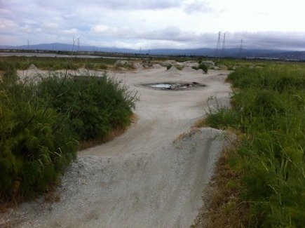
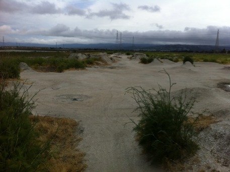
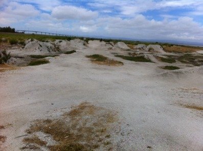
How to find: from 92 (San Mateo bridge) take the Foster City Blvd exit and head south to make a left on E Hillsdale Blvd towards the coast of the bay. Drive about a mile down the coast, south, away from the bridge. Just past the plaza and the school, park on the coast side of the street across from the houses. Walk up the hill to were the walking trail is and you will see the jumps, they are huge! The crawl spot is just a short walk up, across the street from the school and runs all the way up to the bridge.
<br>
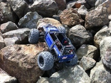
History: heard it's been there for years. I only saw kids bmx-ing in there and they were watching the whole time. There's plenty of space to stay away from bmx-ers. The rocks are large but still doable.
<br>
Google maps: if this link does not work, zoom in to the huge "Foster City" sign just below the bridge. http://maps.google.com/maps/ms?msid=210034830350840113249.0004a7108ac6444763868&msa=0
<br>
Video: http://www.youtube.com/watch?v=I9t-Zhuj2Ow&feature=youtube_gdata_player
http://www.youtube.com/watch?v=XFv_CU2PtPM&feature=youtube_gdata_player
<br>
Pics:
 

Attachments

  • ImageUploadedByTapatalk1309590649.669630.jpg
    ImageUploadedByTapatalk1309590649.669630.jpg
    39.4 KB · Views: 166
  • ImageUploadedByTapatalk1309590667.755304.jpg
    ImageUploadedByTapatalk1309590667.755304.jpg
    36.8 KB · Views: 163
  • ImageUploadedByTapatalk1309590685.639655.jpg
    ImageUploadedByTapatalk1309590685.639655.jpg
    34.2 KB · Views: 169
  • ImageUploadedByTapatalk1309590701.040441.jpg
    ImageUploadedByTapatalk1309590701.040441.jpg
    44.3 KB · Views: 163
  • ImageUploadedByTapatalk1309590721.074765.jpg
    ImageUploadedByTapatalk1309590721.074765.jpg
    52.7 KB · Views: 166
Back
Top